Gander to Washington Flight Time, Distance, Route Map
Flight time from Gander, Canada to Washington, United States is 2 hours 36 minutes under avarage conditions. Our flight time calculator assumes an average flight speed for a commercial airliner of 500 mph, which is equivalent to 805 km/hr or 434 knots. Actual flight times may vary depending on aircraft type, cruise speed, routing, weather conditions, passenger load, and other factors.
What is the Flight Distance Between Gander and Washington?
The flight distance from Gander (Canada) to Washington (United States) is 1307 miles. This is equivalent to 2103 kilometers or 1135 nautical miles. The calculated distance (air line) is the straight line distance or direct flight distance between cities. The nearest airport to Gander, is Gander Airport (YQX) and the nearest airport to Washington, is Ronald Reagan National Airport (DCA).
Gander - Washington Timezones & Time Difference
Current local time in Gander is 2025-08-15, 19:04:51 NDT
Current local time in Washington is 2025-08-15, 17:34:51 EDT.
Time difference between Gander (Canada) and Washington (United States) is 1 Hours 30 Minutes.
Washington time is 1 Hours 30 Minutes behind Gander.
Gander to Washington Flight Route Map
Flight map from Gander, Canada to Washington, United States is given below.Click the map to view Gander to Washington nonstop flight path and travel direction.
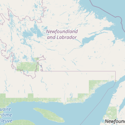                     Leaflet | © OpenStreetMap The distance between cities calculated based on their latitudes and longitudes. This is also called distance as the crow flies. Bird flight distance is calculated by drawing a straight line between two point coordinates. The length of this drawn line will give the shortest distance value. This distance may be very much different from the actual travel distance. Gander GPS Coordinates: Latitude: N 48° 57' 15.9'' Longitude: W 54° 36' 37.3'' Washington GPS Coordinates: Latitude: N 38° 54' 25.9'' Longitude: W 77° 2' 12.7'' Gander Map, Where is Gander located? Washington Map, Where is Washington located? |
Popular Searches from Gander
- Gander to Phoenix flight time, duration and distance
- Gander to Copenhagen flight time, duration and distance
- Gander to Shannon Airport flight time, duration and distance
- Gander to Halifax flight time, duration and distance
- Gander to Sherbrooke flight time, duration and distance
- Gander to Keflavík flight time, duration and distance
- Gander to Havana flight time, duration and distance
- Gander to Reykjavík flight time, duration and distance
- Gander to Toronto flight time, duration and distance
- Gander to Fort Campbell flight time, duration and distance
- Gander to Reykjavík flight time, duration and distance
- Gander to Lisbon flight time, duration and distance
- Gander to Dublin flight time, duration and distance
- Gander to Reykjavík flight time, duration and distance
- Gander to York flight time, duration and distance
- Gander to Dublin flight time, duration and distance
- Gander to Shannon Airport flight time, duration and distance
- Gander to Reykjavík flight time, duration and distance
- Gander to Washington flight time, duration and distance
- Gander to Dublin flight time, duration and distance
Popular Searches from Washington
- Washington to Moscow flight time, duration and distance
- Washington to Anchorage flight time, duration and distance
- Washington to Anchorage flight time, duration and distance
- Washington to Anchorage flight time, duration and distance
- Washington to Anchorage flight time, duration and distance
- Washington to Anchorage flight time, duration and distance
- Washington to Anchorage flight time, duration and distance
- Washington to Anchorage flight time, duration and distance
- Washington to Anchorage flight time, duration and distance
- Washington to Anchorage flight time, duration and distance
- Washington to Anchorage flight time, duration and distance
- Washington to Anchorage flight time, duration and distance
- Washington to Anchorage flight time, duration and distance
- Washington to Anchorage flight time, duration and distance
- Washington to Anchorage flight time, duration and distance
- Washington to Anchorage flight time, duration and distance
- Washington to Anchorage flight time, duration and distance
- Washington to Anchorage flight time, duration and distance
- Washington to Anchorage flight time, duration and distance