Ottawa to Miami Flight Time, Distance, Route Map
Flight time from Ottawa, Canada to Miami, United States is 2 hours 45 minutes under avarage conditions. Our flight time calculator assumes an average flight speed for a commercial airliner of 500 mph, which is equivalent to 805 km/hr or 434 knots. Actual flight times may vary depending on aircraft type, cruise speed, routing, weather conditions, passenger load, and other factors.
What is the Flight Distance Between Ottawa and Miami?
The flight distance from Ottawa (Canada) to Miami (United States) is 1381 miles. This is equivalent to 2223 kilometers or 1200 nautical miles. The calculated distance (air line) is the straight line distance or direct flight distance between cities. The nearest airport to Ottawa, is Rockcliffe St. Airport (YRO) and the nearest airport to Miami, is Miami International Airport (MIA).
Ottawa - Miami Timezones & Time Difference
Current local time in Ottawa is 2025-08-04, 01:47:09 EDT
Current local time in Miami is 2025-08-04, 01:47:09 EDT.
Time difference between Ottawa (Canada) and Miami (United States) is 0 Hours.
Ottawa to Miami Flight Route Map
Flight map from Ottawa, Canada to Miami, United States is given below.Click the map to view Ottawa to Miami nonstop flight path and travel direction.
      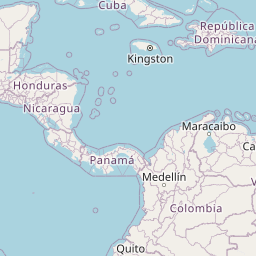          Leaflet | © OpenStreetMap The distance between cities calculated based on their latitudes and longitudes. This is also called distance as the crow flies. Bird flight distance is calculated by drawing a straight line between two point coordinates. The length of this drawn line will give the shortest distance value. This distance may be very much different from the actual travel distance. Ottawa GPS Coordinates: Latitude: N 45° 25' 17.5'' Longitude: W 75° 41' 49.9'' Miami GPS Coordinates: Latitude: N 25° 45' 42'' Longitude: W 80° 11' 30.4'' Ottawa Map, Where is Ottawa located? Miami Map, Where is Miami located? |
Popular Searches from Ottawa
- Ottawa to Narita flight time, duration and distance
- Ottawa to Brest flight time, duration and distance
- Ottawa to Kainuu flight time, duration and distance
- Ottawa to Vladivostok flight time, duration and distance
- Ottawa to Dublin flight time, duration and distance
- Ottawa to Chicago flight time, duration and distance
- Ottawa to Halifax flight time, duration and distance
- Ottawa to Winnipeg flight time, duration and distance
- Ottawa to Reykjavík flight time, duration and distance
- Ottawa to Paris flight time, duration and distance
- Ottawa to Tokyo flight time, duration and distance
- Ottawa to Cancún flight time, duration and distance
- Ottawa to Honolulu flight time, duration and distance
- Ottawa to Nuuk flight time, duration and distance
- Ottawa to Washington flight time, duration and distance
- Ottawa to Calgary flight time, duration and distance
- Ottawa to Magadan flight time, duration and distance
- Ottawa to San Diego flight time, duration and distance
- Ottawa to Montreal flight time, duration and distance
- Ottawa to Costa Rica flight time, duration and distance
Popular Searches from Miami
- Miami to Amsterdam flight time, duration and distance
- Miami to Singapore flight time, duration and distance
- Miami to Melbourne flight time, duration and distance
- Miami to New York flight time, duration and distance
- Miami to St. Petersburg flight time, duration and distance
- Miami to Saint Lucia flight time, duration and distance
- Miami to Nairobi flight time, duration and distance
- Miami to Key West flight time, duration and distance
- Miami to Tbilisi flight time, duration and distance
- Miami to Panama City flight time, duration and distance
- Miami to Bahamas flight time, duration and distance
- Miami to Jacksonville flight time, duration and distance
- Miami to Edmonton flight time, duration and distance
- Miami to San Francisco flight time, duration and distance
- Miami to New York flight time, duration and distance
- Miami to Lima flight time, duration and distance
- Miami to Los Angeles flight time, duration and distance
- Miami to Nassau flight time, duration and distance
- Miami to Governor's Harbour flight time, duration and distance