Melbourne to Cambridge Flight Time, Distance, Route Map
Flight time from Melbourne, Australia to Cambridge, United States is 20 hours 28 minutes under avarage conditions. Our flight time calculator assumes an average flight speed for a commercial airliner of 500 mph, which is equivalent to 805 km/hr or 434 knots. Actual flight times may vary depending on aircraft type, cruise speed, routing, weather conditions, passenger load, and other factors.
What is the Flight Distance Between Melbourne and Cambridge?
The flight distance from Melbourne (Australia) to Cambridge (United States) is 10226 miles. This is equivalent to 16457 kilometers or 8880 nautical miles. The calculated distance (air line) is the straight line distance or direct flight distance between cities. The nearest airport to Melbourne, is Essendon Airport (MEB) and the nearest airport to Cambridge, is Cambridge Airport (CGE).
Melbourne - Cambridge Timezones & Time Difference
Current local time in Melbourne is 2025-09-01, 12:38:15 AEST
Current local time in Cambridge is 2025-08-31, 22:38:15 EDT.
Time difference between Melbourne (Australia) and Cambridge (United States) is 14 Hours.
Cambridge time is 14 Hours behind Melbourne.
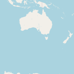
Melbourne to Cambridge Flight Route Map
Flight map from Melbourne, Australia to Cambridge, United States is given below.Click the map to view Melbourne to Cambridge nonstop flight path and travel direction.
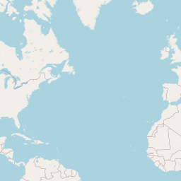         Leaflet | © OpenStreetMap The distance between cities calculated based on their latitudes and longitudes. This is also called distance as the crow flies. Bird flight distance is calculated by drawing a straight line between two point coordinates. The length of this drawn line will give the shortest distance value. This distance may be very much different from the actual travel distance. Melbourne GPS Coordinates: Latitude: S 37° 48' 50.8'' Longitude: E 144° 57' 47.8'' Cambridge GPS Coordinates: Latitude: N 38° 33' 47.4'' Longitude: W 76° 4' 43.8'' Melbourne Map, Where is Melbourne located? Cambridge Map, Where is Cambridge located? |
Popular Searches from Melbourne
- Melbourne to Vancouver flight time, duration and distance
- Melbourne to New York flight time, duration and distance
- Melbourne to Vancouver flight time, duration and distance
- Melbourne to Adelaide flight time, duration and distance
- Melbourne to Dubai flight time, duration and distance
- Melbourne to Belgrade flight time, duration and distance
- Melbourne to Auckland flight time, duration and distance
- Melbourne to Cairns flight time, duration and distance
- Melbourne to Hobart flight time, duration and distance
- Melbourne to Durban flight time, duration and distance
- Melbourne to Auckland flight time, duration and distance
- Melbourne to Jacksonville flight time, duration and distance
- Melbourne to Anse Reunion flight time, duration and distance
- Melbourne to La Réunion flight time, duration and distance
- Melbourne to Phuket flight time, duration and distance
- Melbourne to Japan Shasha flight time, duration and distance
- Melbourne to Doha flight time, duration and distance
- Melbourne to Colombo flight time, duration and distance
Popular Searches from Cambridge
- Cambridge to Karachi flight time, duration and distance
- Cambridge to San Diego flight time, duration and distance
- Cambridge to Berkeley flight time, duration and distance
- Cambridge to East Hanover flight time, duration and distance
- Cambridge to Brisbane flight time, duration and distance
- Cambridge to Barcelona flight time, duration and distance
- Cambridge to Allentown flight time, duration and distance
- Cambridge to Houston flight time, duration and distance
- Cambridge to San Francisco flight time, duration and distance
- Cambridge to Heidelberg flight time, duration and distance
- Cambridge to Horsham flight time, duration and distance
- Cambridge to Allschwil flight time, duration and distance
- Cambridge to San Francisco flight time, duration and distance
- Cambridge to San Jose flight time, duration and distance
- Cambridge to Newark flight time, duration and distance
- Cambridge to Baltimore flight time, duration and distance
- Cambridge to Durham flight time, duration and distance
- Cambridge to Chicago flight time, duration and distance
- Cambridge to Hamburg flight time, duration and distance